


TMV2022 - Etape 3

Vacs
User
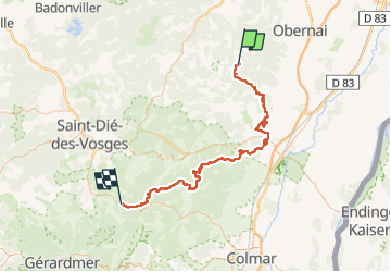

Length
79 km

Max alt
1125 m

Uphill gradient
2308 m
Km-Effort
110 km

Min alt
188 m

Downhill gradient
2287 m
Boucle
No
Creation date :
2022-04-20 10:43:03.238
Updated on :
2022-04-20 11:34:10.901
23m
Difficulty : Easy

FREE GPS app for hiking
 SityTrail
IGN / Geographical institutes
SityTrail Plus
The world is yours!
About
Trail Mountain bike of 79 km to be discovered at Grand Est, Bas-Rhin, Le Hohwald. This trail is proposed by Vacs.
Positioning
Country:
France
Region :
Grand Est
Department/Province :
Bas-Rhin
Municipality :
Le Hohwald
Location:
Unknown
Start:(Dec)
Start:(UTM)
376128 ; 5362483 (32U) N.
Comments